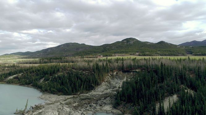
The presence of an active retrogressive thaw slump (RTS) adjacent to the Alaska Highway at km 1456 has created a unique opportunity for permafrost characterization, monitoring, and climate change analysis in the greater Whitehorse area. The RTS was identified in April 2019 during a field study led in partnership with the Yukon Geological Survey (YGS). The slump developed on the hillslope along the shoreline of the Takhini River. Permafrost in this area is discontinuous and found in sporadic, isolated patches that can be significantly ice-rich and thaw-sensitive. This RTS is located 200 m west of another RTS that was initiated prior to 1979 and partially stabilized by 2004. Between these two features stands a wooded area showing signs of slope instability (collapsed trees, cracking) where a third RTS may soon develop.
The purpose of this study was to act before any serious damage occurs and seize the opportunity of the site being located near the city center to develop an intensive research program at a low cost. The objective was to develop an innovative research program around this RTS site that will:
-
develop a better understanding of retrogressive thaw slumps that impact road corridors in the North
-
develop and test a multi-technical monitoring approach using complementary instrumentation for RTSs that will eventually be used for the development of geohazard alarm systems
-
inform an approach to mitigate the threat caused by RTSs on road corridors
-
engage Yukon transportation professionals and Yukon University students in order to advance their understanding of the threats posed by RTS’s; their lessons learned can then be applied to RTS’s in more remote locations.
 The Takhini River Thaw Slump is located in Takhini Valley at km 1456 of the Alaska Highway, approximately 34 km west of Whitehorse airport by road. This thaw slump likely developed in 2013 or 2014 because of exposure of ice-rich permafrost due to bank erosion along the south bank of the Takhini River.
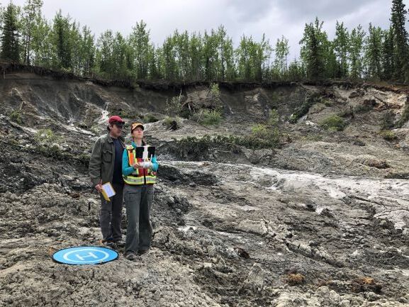
To achieve the project objectives, several research activities were carried out on site, including:
-
drilling boreholes, from the RTS to the right of way, instrumented with ground temperature cables, soil moisture sensors, and inclinometer arrays to monitor ground parameters and RTS failure in real-time
-
analyzing borehole samples for grain size distribution and excess ice content
-
monitoring ground surface movement with differential GPS (DGPS) measurements tying in with benchmarks and existing legal survey pins and establishing surface survey monuments
-
imaging and topography monitoring using Unmanned aerial vehicle (UAV) photogrammetry
-
two-dimensional Electrical Resistivity Tomography (ERT) surveying
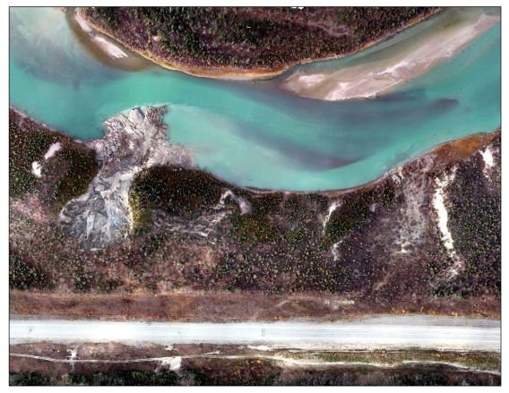
The monitoring of the ground movement is an ongoing monthly activity from May to October. Thirty-three benchmarks have been installed adjacent to the thaw slump and their position is measured with a highly precise GPS. These positions are mapped and compared month after month. Some benchmarks haven’t moved at all and some others located to the east of the thaw slump have shown a movement of up to 1.65 m towards the Takhini River between May 2019 and May 2021. This demonstrates the amplitude of the ground movement even outside of the thaw slump itself. The progression of the thaw slump headwall has been monitored by collecting drone images to create high resolution aerial photo mosaics of the site. These are used to map the headwall location, thus showing the advancement over time and quantifying the speed of its progression. The thaw slump has been progressing towards the highway at an average rate of up to 11 metres per year between 2014 and 2020.
The geotechnical boreholes and ERT data are consistent in defining how far down the permafrost is found and the permafrost thickness (2-3 m depth). The soil/permafrost cores collected on site show the presence of clayey silts, which are frost susceptible, because clay adsorbs water, down to at least 25 meters in depth. The temperature data suggest that the permafrost is warm, i.e. close to 0°C, and therefore vulnerable to thaw. The geophysical and geotechnical data showed thick, ice-rich permafrost at the headwall of the thaw slump and more sporadic clusters of ice-rich permafrost closer to the road. This difference in permafrost thickness could be explained by decades of permafrost degradation under the right of way of the Alaska Highway since its construction in 1942. However, the ERT data suggest that permafrost could still be present on the southern side of the highway.
Geophysical and borehole data emphasize the ice-rich nature of the ground at this site, as well as the presence of ground water flows. While the thaw processes may have been initiated by bank erosion on the Takhini River, they have been exacerbated by the high ground-ice content and the thermal effect of ground water springs circulating within the ice-rich clusters. Irrigation of the farmland located on the other side of the highway in the summertime may contribute to the degradation processes. Also, the inclinometer data suggest that the slump eroded in one quick event rather than through slow incremental erosive processes. All together, these records suggest that ground temperature and inclinometer data could be used as an anticipatory warning of failure for a specific point many days before a catastrophic event. Remote daily monitoring of this data could be used in an alarm system to trigger an alert for an upcoming collapse. Such a system could be used to monitor the thaw slump as it progresses towards the highway and help the highway operator ensure public safety. The research team are in the process of trying an alarm prototype this year.
Dr. Fabrice Calmels, Research Chair in Permafrost & Geoscience, YukonU Research Centre
Louis-Philippe, Research Professional, Permafrost & Geoscience, YukonU Research Centre
Cyrielle Laurent, GIS Technician, Permafrost & Geoscience, YukonU Research Centre
Fanny Amyot, Permafrost Researcher, Permafrost & Geoscience, YukonU Research Centre
Cathy Koot, Project Officer, YukonU Research Centre